
 IRIS Earthquake Browser – SOUTHERN CALIFORNIA: I have noticed during the last month that earthquakes are springing up a great deal in California as well as the entire North/South America continents. There have been a number of medium sized quakes along the entire Atlantic ridge which is where the tectonic plates are spreading. As this occurs, it shoves the continents over the Pacific Plate and other oceanic plates.
This, in turn, also squeezes the plate on which most of the West Coast of North America resides. This plate, unlike the North and South American Plates, is moving northwards at a very accelerated pace which causes frequent, violent lurches. Magnitude-5.1 earthquake shakes Los Angeles area today as the tension tries to release on all the fault lines that radiate out from the San Andreas edge. Here is how the quake is traveling today based on the time of quakes:  California has some of the finest geologists who like working there because it is so geologically active and fascinating. They give us reams and reams of information such as these maps: Earthquake map: California Geological Survey releases map containing 50 new faults in California – Los Angeles LA | Examiner.com
About 50 new faultlines have been discovered over the past 20 years and more are sure to be discovered. Some Earthquakes strike in locations where faultlines are not yet documented, including one near Lake Matthews in Corona, California. A chain of hills runs from Lake Mathews to the Eastern Norco zones near the Santa Ana River. These hills have micro-quakes every week. USGS has not yet done a study on these hills yet.

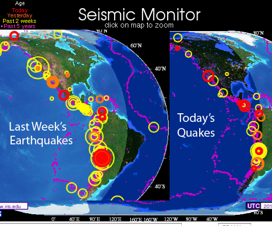
The above satellite map shows the neighborhood where today’s quakes are happening. Naturally, the most dangerous places in California are the most heavily populated as politicians and voters both studiously ignore the geologists. All the geologists can do is issue dire warnings regularly. People love living where it is WARM. This is why I am so absolutely annoyed with the global warmists.
If this were Minnesota, the population levels would be very low if it were also so geologically violent as well as freezing cold. California is stuffed to the gills with giddy people who want to live where it is always warm and they never have to shovel snow. Like Naples and Tokyo, both of which are virtually doomed to annihilation due to tsunamis, volcanoes and earthquakes, LA wants to pretend this isn’t suicide city.
The astonishing fact is, people deliberately move as close as possible to catastrophe due nearly entirely the weather in these places is balmy, not too hot nor cold. Perfection for humans aside from the disasters that lurk in the future and which happened regularly in the past. California Geological Survey – Regional Geologic Mapping Program
The seismic hazard map and model presented in this report indicate that the hazard is high in many regions across the state, especially within about 50 km of the San Andreas fault system, the Eastern California Shear Zone faults, the western Transverse Ranges, and the Cascadia subduction zone. Earthquakes in populated regions have already caused considerable losses during the past 2 centuries that span California’s recorded seismic history.
The hazard map is consistent with this historical seismicity, the historical damage patterns, and with geologic information regarding the slip rate and pre-historic earthquakes. This study indicates that about three-fourths of California’s population resides in counties that have significant seismic hazard.
This level of hazard reaffirms the need to examine existing infrastructure and verify that it is adequate to withstand the expected seismic shaking to prevent loss of life from structural collapse during an earthquake. The seismic hazard maps and models presented in this report should be useful for assisting policy makers, engineers, and scientists to plan for strong earthquake ground shaking. Here is the hazard map:
 See? 75% of the population in California lives where the most danger dwells. And they are mostly blissfully unaware of the dangers. My family lived in California since the Gold Rush and had experienced quite a few quakes.
My grandfather used to fret about all the ‘fools’ who came to LA. He watched that city grow from a sleepy backwater in 1860 to the nightmare monster it is today. He was not only an astronomer but worked a great deal with geologists who were just figuring out how plate tectonics worked when he died.
The economic disaster that California will cause us all is huge. It will push the US much deeper into debt since our entire economic system runs on red ink from top to bottom unlike Putin’s Russia.

 Email:
emeinel@fairpoint.net
MAILING ADDRESS:
EMS NEWS
P.O. BOX 483
BERLIN, NY 12022
Make checks out to ‘Elaine Supkis’
Click on the Pegasus icon on the right sidebar to donate via Paypal.


Reblogged this on abraveheart1.
“People die all the time, just like that. Why, you could wake up dead tomorrow! Well, good night.” –Homer Simpson.
I felt the quake. It was mild.
Yes, it is a mild earthquake as are all harbinger quakes. For a three year period before the Great Tohoku Quake in Japan there were these odd minor tremors. Then boom!
Yes, unless I move, there is not much I can do. I was hoping for a few ‘medium’ ones to release pressure.
Nope, the one that is locked and loaded continues this way until the trigger is pulled. Aka, the San Andreas. Over 300 years and overdue.
These earthquakes are NOT centered around the La Brea Tar Pits, those are in LA! The earthquakes you are describing are happening in Orange County, CA in a city named Brea!! Get. Your facts correct!
http://www.latimes.com/local/lanow/earthquake-44-quake-strikes-near-rowland-heights-california-hc7udj,0,7895131.story#axzz2xP4EWBh6
Pingback: 4 Things to Know About Earthquakes -
Not in La Brea but in “Brea”–seriously, that too much yo figure out via “investigative” reporting?